Maui
The island of Maui is the second-largest of the Hawaiian Islands at 727.2 square miles (1,883 km2) and is the 17th largest island in the United States. Maui is part of the State of Hawaiʻi and is the largest of Maui County's four islands, bigger than Molokaʻi, Lānaʻi, and unpopulated Kahoʻolawe.
Location
Maui, Hawaiʻi
Our family had the privilege of living on the Hawaiʻian island of Maui for several years, and here are some of the observations and favorite places that we wanted to share to help you enjoy this enchanting place. Keep in mind that we are not attracted to the typical tourist venues and prefer by far more authentic experiences, but Maui can definitely cater to both sets of preferences.
Despite being a relatively small island, Maui offers a veriety of climates cause by the trade winds from the northeast. The Hāna side of the island offers a rich, lush tropical rainforest and frequent rains, the high altitude of Haleakalā offers a cold mountain climate, and the Kihei side is mostly dry with very few rainy days.
But to really appreciate the Aloha spirit of the island, everyone must learn to appreciate and respect the Hawaiʻian culture, traditions, and people. Let's start by learning a bit about the island's history.
History
The first Polynesians are thought to have arrived in Hawaiʻi in the 3rd century from the Marquesas Islands and were followed by Tahitians in AD 1300, who then forced the original inhabitants into remote valleys. Stories about the Menehune, little people who built heiau and fishponds, seem to support the existence of ancient peoples who settled the islands before the Hawaiians. They were exceptional seafarers who mastered advanced celestial navigation techniques, ocean currents, and could discover islands by studying birds and sea life patterns as well as careful analysis of water reflection on clouds.
A strong social bond was also a contributor in making this seemingly impossible journey across 2,400 miles of open ocean possible. The Tahitians introduced the kapu system, a strict social order that affected all aspects of life and became the core of Hawaiʻian culture.
Because ancient Hawaiʻians did not have a written language, they used hulas to keep their stories alive and to preserve their genealogy, history, and myths from generation to generation. Each element carries meaning, every movement, the speed at which they swing their hips, the direction their wrist circles, the rhythm, every beat is part of the story. In Hawaiʻian mythology, Māui is a great folk hero and trickster who is credited with the creation of the Hawaiian islands when he went on a fishing expedition with his friends, and, using a magic fish hook, pulled up the various island groups from the ocean depths.
On November 26, 1778, explorer James Cook became the first European to set sight on Maui but never set foot on the island because he was unable to find a suitable landing. The first European to visit Maui was the French admiral Jean-François de Galaup, Comte de Lapérouse, who landed on the shores of what is now known as La Perouse Bay on May 29, 1786. Within a few decades after the first contact, the native Hawaiians were nearly wiped out by diseases introduced to the islands because they didn't have any immunity to them.
Modern Hawaiʻian history really began in the mid-18th century. Kamehameha I, king of the independent island of Hawaiʻi, conquered the independent islands of Oʻahu, Maui, Molokaʻi, and Lānaʻi and unified them under one government. In 1810, the entire Hawaiian archipelago became unified when Kauaʻi and Niʻihau joined the Hawaiian Kingdom voluntarily. Two major dynastic families ruled the kingdom: the House of Kamehameha and the House of Kalākaua.
Even though Hawaiʻi was the first non-European indigenous state whose independence was recognized by the major powers, it struggled on several occasions to protect itself from foreign powers seizing control. And in 1893, several local businessmen and politicians, attempting to benefit from more favorable trade conditions, falsely claimed an "imminent threat to American lives and property", and managed to summon uniformed U.S. Marines to overthrow the queen and her government. Hawaiʻi was formally annexed through the Newlands Resolution, which was passed on July 4, 1898, to create the Territory of Hawaii. United States Public Law 103-150 adopted in 1993 (informally known as the Apology Resolution), acknowledged that "the overthrow of the Kingdom of Hawaii occurred with the active participation of agents and citizens of the United States" and also "that the Native Hawaiian people never directly relinquished to the United States their claims to their inherent sovereignty as a people over their national lands, either through the Kingdom of Hawaii or through a plebiscite or referendum.

© Copyrigh 2026 Laki Maikaʻi. All rights reserved.
Kahului and the ʻĪao Valley
Kahului is home to Maui's main airport but is not generally considered a tourist destination. Some of the most notable attractions are the Queen Ka'ahumanu Shopping Center and the Maui Arts & Cultural Center.
For fresh local goods and products, don't miss the Maui Swap Meet every Saturday morning in Kahului from 7 am to 1 pm.
For the more adventurous-minded, don't miss a visit to Kite Beach at the western end of Kanaha Beach, a great place for kiteboarding.
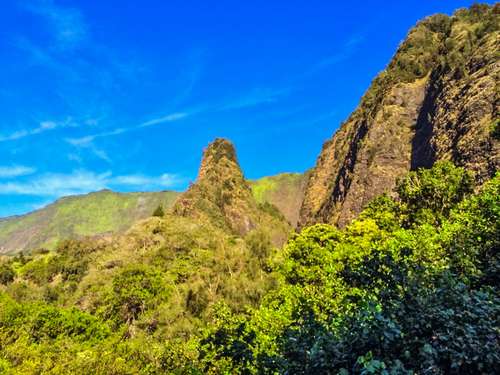
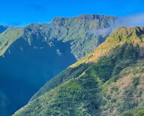
The ʻĪao Valley Monument State Park is a lush, stream-cut valley in the West Maui mountains located just a few miles west of Wailuku. Because of its natural beauty and historical significance, this site has become a popular tourist location and is the home of the ʻĪao Needle, one of the most recognized symbols of Maui. The cliffs of the West Maui Mountains are actually part of an extinct volcano.
In 1790, the Battle of Kepaniwai took place there, in which Kamehameha the Great defeated Kalanikūpule and the Maui army during his campaign to unify the islands. The battle was said to be so bloody that dead bodies blocked ʻĪao Stream, and the battle site was named Kepaniwai ("the damming of the waters").
Visitors can also take a short paved trail (ʻĪao Needle Lookout Trail and Ethnobotanical Loop) through the valley's dense rainforest to a small overlook in order to take a closer look at the ʻĪao Needle (Kūkaemoku), the park's famous landmark (30 minutes).
The Puʻu Kukui summit area at the valley's head receives an average of 386 inches (9.8 m) of rainfall per year, making it the second wettest location in the State. Much of this rainfall ends up flowing into the ʻĪao Stream.
The Kepaniwai Park's Heritage Gardens is worth a stop. The park memorializes Maui's multicultural history with scale models of ethnic buildings and gardens representing the immigration of Hawaiian, an American missionary, Chinese, Japanese, Portuguese, Korean, and Filipino cultures.
Further North is the Waihee Ridge Trail, one of the best hikes on Maui and our absolute favorite.

© Copyrigh 2026 Laki Maikaʻi. All rights reserved.
Haleakalā
Haleakalā or the East Maui Volcano is a massive dormant shield volcano that forms more than 75% of the Hawaiian Island of Maui, the second-largest of the Hawaiian Islands, and also one of the world's largest volcanic craters.
The western 25% of the island is formed by another volcano, Mauna Kahalawai, also referred to as the West Maui Mountains.
Towering over the island of Maui and visible from just about anywhere on the island, Haleakalā is an imposing natural feature. At 10,023 feet above sea level, this dormant volcano sets the stage for a myriad of breathtaking sceneries. In Hawaiʻian folklore, the depression (crater) at the summit of Haleakalā was home to the grandmother of the demigod Māui. According to the legend, Māui's grandmother helped him capture the sun and force it to slow its journey across the sky in order to lengthen the day. Early Hawaiʻians used the name Haleakalā ("house of the sun") to the general mountain. Haleakalā is also the name of a peak on the southwestern edge of Kaupō Gap.
Despite its imposing height, Haleakala's gentle and graceful slopes allow visitors to drive all the way up to the Haleakala Visitor Center near the summit (9,740 feet). The long and winding road to the Haleakala National Park is well worth the effort. Experiencing the sunrise from the summit of Haleakala on a clear morning is an unforgettable experience.

© Copyrigh 2026 Laki Maikaʻi. All rights reserved.
The Halemau’u Trail
There are many great hiking trails to choose from to discover the inside of the crater. The Halemau’u Trail is our favorite for a day hike. It follows the steep and narrow path down to the lower part of the Haleakalā crater.
Check the park website for closures and current conditions. The trailhead start is located on the Haleakalā Highway (Hwy. 378) between mile markers 14 and 15. Access to the park is now restricted between the hours 3 am to 7 am each day. If you want to get an early start you'll have to use the permit lottery system for getting into the park during the popular sunrise viewing times, even if you just want to hike. If you arrive at the park after 7 am, no permit is needed but you'll still have to pay the park entrance fee. Drive carefully along the Haleakalā Highway, a popular activity is for groups of tourists to cycle down the steep, narrow, winding road while sightseeing. If you are lucky enough to be able to book one of the highly coveted camping cabins, you can spend a night and hike multiple days. Otherwise, a day hike will have to suffice.
Be aware that the high altitude will affect you and will make your hike more difficult. Along the way, you’ll surely be able to see silverswords (ʻāhinahina), amazing plants found only there that have uniquely adapted to the harsh conditions of the crater. They live between 3 to 90 years and only flower once, shooting up a spectacular flowering stalk and scattering seeds in the wind before dying soon after. If you're lucky, you'll also see a Nēnē, the Hawaiʻian Goose.
The hike described below travels down the Halemau’u Trail to an ʻāhinahina (Haleakalā silversword) loop. This hike follows the amazing trail down the cliffs of the crater. You’ll marvel at the way it hugs the contours of the cliff walls to provide a relatively easy path down to the crater below. The views of the crater are huge on a clear day. People with an extreme fear of heights might want to skip this one.
The hiking trails also extend all the way down to Hana, through the tropical rainforest. On the Hana side, the Haleakalā National Park extends to the Kīpahulu District, which can be accessed by driving 12 miles past the town of Hāna. ʻOheʻo Gulch, also known as the "Seven Sacred Pools", is a series of waterfalls and pools located inside the Haleakala National Park.
Above this area, visitors can enjoy a hike along the Na’ili’ili Haele Stream & Waterfalls (aka “Bamboo Forest”), a short but well worth it hike.
Lāhainā and Kāʻanapali
Lahaina was the original capital of the Kingdom of Hawaiʻi until it was permanently moved to Honolulu. Lahaina also has a darker past as the center of the global whaling industry in the 19th century. Today, the waters between the islands of Maui, Lanai, and Molokai are part of a protected humpback whale sanctuary and offer a fantastic experience for anyone wanting to observe and learn more about these magnificent creatures.
Lahaina's waterfront, Front Street, has been ranked one of the "Top Ten Greatest Streets" by the American Planning Association and is home to many restaurants that offer a broad variety of food and entertainment, making the street the hub of West Maui's nightlife.
Some of the most notable sites include the banyan tree in Courthouse Square, which features an exceptionally large banyan tree (Ficus benghalensis) planted in 1873, the Baldwin House Museum, a historical landmark completed in 1835, the Wo Hing Temple Museum, a remaining trace of Lahaina's rich Chinese past, the Lahaina Jodo Mission, and shops, as well as free Hula, Shows at the Lahaina Cannery Mall.
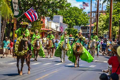
Lahaina's is also home to the Na Kamehameha Commemorative Pa’u Parade and Ho’olaule’a, which typically draws a procession of decorated horses and riders to Front Street in Lahaina, and is held every year in June.
Halloween is a major celebration in Lahaina and has become a signature event in the past decades, with crowds averaging between 20,000 to 30,000. It is however said to be more of an adult party and somewhat inappropriate for kids.
And there is of course the famous Old Lahaina Luau and the Ulalena show by Maui Theatre.
Don't forget to stop for a free degustation of the MauiGrown Coffee grown on the Ka'anapali Estate.
A short distance North of Lahaina is the renowned Kaanapali and Napili bay. While they are absolutely beautiful, they are home to many luxury hotels and represent the more "commercial" and "touristy" side of Maui and feel much less authentic, but it is a matter of preference.
Further North is the beautiful Honolua-Mokulē‘ia Bay, a great surfing spot often visited by dolphins. The road continues all the way to Kahului, but access is not recommended because the winding road narrows to one lane.
Kihei
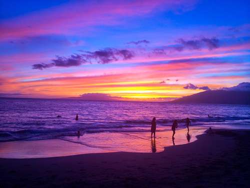
Kihei is located on Maui’s southwest shore, on the leeward side of Haleakala's gentle slopes. This area offers the sunniest and driest weather on the island all year long, which makes it a perfect vacation destination. Kihei also offers clear views of the islands of Kahoʻolawe, Molokini, Lanaʻi as well as the West Maui mountains. The area also has many lifeguarded beaches with calm waters that are perfect for swimming, snorkeling, and boogie boarding. Most beaches also have free public showers, and many are adjacent to parks with picnic tables, which makes them the perfect stop to watch some of Maui's best sunsets.
Some of the most notable beaches in the area, to name a few, are Kalama Beach Park which offers 36 acres of shady oceanfront lawns and palm trees and is often the location of choice for craft fairs, music concerts, and other events.
There are also the Kamaole Beaches, commonly referred to as Kam 1,2, and 3, Keawakapu Beach, Charlie Young Beach, Mokapu Beach Park, and Big Beach and Makena beach. Beaches are usually calmer in the morning hours and are best for snorkeling and looking for green and hawksbill sea turtles (remember that it is illegal in Hawaii to get too close to them). Who knows, you may even see a Humuhumunukunukuapua`a, the Hawaiʻi State fish! The trade winds usually kick up in the afternoon and create increased surf activity best for boogie boarding.
You can also view a live picture of the Keawakapu beach Webcam and many other Kihei beach Webcams. Please be advised that the shores of Hawaii can be potentially dangerous, remember to check with the lifeguards for updates on the current and ocean conditions before entering the water. Never turn your back on the ocean when you are on the shoreline, and never enter the water if it is murky and offers poor visibility as this is usually associated with increased shark activity which can provide potential harm to people entering the water.
During the whale season, which typically runs from October to May, whales can often be seen breaching not too far from the shore and offer spectacular displays. If you want to take a closer look, as you undoubtedly will want to, the Pacific Whale Foundation" in Maalaea (just North of Kihei) offers many whale watching expeditions, charter fishing excursions, as well as snorkeling trips to Molokini. Also, don't forget to check their Maui Volunteers on vacation program for other fun adventures. The Maalaea Harbor Village is also the home of the Maui Ocean Center where you can experience and learn more about the Hawaii reef and its abundant sea life.
Kihei is also home to the Hawaiian Islands Humpback Whale National Marine Sanctuary, which is jointly managed by the National Oceanic and Atmospheric Administration and the State of Hawai`i. The visitor center is an ideal spot to learn about the marine environment and even see humpback whales breaching. This scenic beachfront location at the foot of Haleakalā has views of Kahoʻolawe, Lānaʻi and West Maui looking across the waters of the sanctuary. The center contains a wealth of information about humpback whales. While you are there, don't forget to see the Kōʻieʻie fishpond, which was built over 500 years ago, and its stone walls are still maintained as an important link to traditional Hawaiʻian practices.
Head to the Azeka Mauka shopping center parking lot for the Maui Fourth Friday of each month in Kihei from 6 to 9 PM for free music with vendors, food trucks, restaurant specials. Don't miss the free events at the upscale Wailea Wednesday at the Shops at Wailea, check their schedule for details. Wailea is also the home of the annual Maui Film Festival.
South of Wailea and Makena, at the South end of South Kihei road is La Perouse bay, named after French explorer Captain Jean-François de Galaup, comte de La Pérouse. La Pérouse is said to be the first westerner to have set foot on Maui in 1786. The area near the bay is also the site of Maui's most recent volcanic activity and the lava fields create a surreal landscape. The site lies directly south of the Ahihi-Kinau Natural Area Reserve and is home to many endemic and other fish species, marine mammals, green sea turtles, and coastal plants. The parking lot also marks the start of the King's Highway or the Hoapili trail, a trail that circumnavigated the island. After a short hike on the trail visitors will discover many archaeological sites, including fishing shrines, salt pans, and heiau, or religious platforms. Read the Trip Advisor reviews about La Perouse Bay.

© Copyrigh 2026 Laki Maikaʻi. All rights reserved.
The Road to Hāna
Life is a journey, not a destination, and so is the road to Hāna. The many wonderful places you will discover along the way will surely make the trip to Hāna an unforgettable experience. By traveling this 55-mile drive through the unspoiled Eastern coast of Maui, you will find the journey’s end at every step of the road.
Some of the most notable places to see along the way, just to name a few, are Twin Falls, the Garden of Eden Arboretum, the Keanae Arboretum, and the Keanae bay, the Pua'a Ka'a Falls, and Makapipi Falls.
The Hāna Highway was featured in National Geographic's Drives of a Lifetime Series. It is usually done in a clockwise direction around eastern Maui. There are many guidebooks that document the many attractions that can be found along the way, which include picturesque views of spectacular waterfalls, rugged shorelines, dense coastal rainforest, and some of the best beaches on the island. As a start, try visiting the roadtohana.com website. The drive can be done in as little as 2 hours but will take much longer if you stop along the way, so plan on an all-day trip! Also note that there is no rainforest without rain, which you will most likely encounter along the way, so be prepared.
The town of Hāna itself is isolated from the rest of the island and offers a sharp contrast with the overdeveloped side of the island. It is a charming community that has managed to preserve the small-town atmosphere blended with Hawaiian culture, and most importantly, to preserve the natural scenic beauty of the area.
Don't miss to stop to visit the Wai'anapanapa State Park. Waiʻanapanapa means "glistening fresh water" in the Hawaiian language, referring to nearby fresh water streams and sparkling pools. The park is also home to the Waianapanapa Black Sand Beach. Hamoa Beach is also worth a stop along the way.
The Kīpahulu District of the Haleakalā National Park can be accessed by driving 12 miles past the town of Hāna, shortly after passing the Wailua Falls (also well worth a stop). ʻOheʻo Gulch, also known as the "Seven Sacred Pools", is a series of waterfalls and pools located inside the Haleakala National Park.
Above this area, visitors can enjoy a hike along the Na’ili’ili Haele Stream & Waterfalls (aka “Bamboo Forest”), read reviews on Yelp.
If you decide to go "all the way" around the eastern coast of Maui, please note that the dirt road past Route 31 is occasionally closed to traffic due to landslides. Your rental car contracts may not allow driving this section of the road. However, although some sections are unpaved and somewhat rough, it is not a daunting road if taken slowly.

© Copyrigh 2026 Laki Maikaʻi. All rights reserved.
Pa’ia and Upcountry
On the north side of Maui, you will find Pa’ia, a lovely little beach town with typical wooden buildings serving as reminders of the town's past as a sugar plantation. Paia offers a wide array of specialty shops, fine boutiques, antique stores, surf shops, bakeries, restaurants, etc.
A few minutes east of Paia, you will find Hookipa Beach Park, the windsurfing capital of the world. An exposed reef runs along most of the shore break, and frequently Hawaiian Green Sea Turtles (Honu) can be seen resting just on the other side.
Kula is a district of Maui that stretches across the "up-country", the western-facing slopes of Haleakalā, from Makawao to Ulupalakua.
Makawao is located on the rural northwest slope of Haleakala on East Maui. The town is known for being the heart of an area known as "Upcountry Maui", a part of the island dominated mostly by agriculture and ranch land. Makawao is the biggest little town upcountry and is famous for its Hawaiian cowboys, or paniolo. Since the late 19th century, horseback-riding paniolo has wrangled cattle in Maui’s wide-open upland fields. The Makawao Rodeo, held yearly on the Fourth of July, is Hawaii's largest paniolo competition and has been an Upcountry tradition for more than 50 years. The weekend events include a parade and traditional rodeo competitions such as barrel racing, calf roping, and bareback bronco riding, all with a few Hawaiian twists.
Pukalani is located directly across from Makawao. In Hawaiʻian, Pukalani means "hole in the heavens". Clouds form above and below the community on Haleakalā, leaving Pukalani sunny most of the time. For fresh local fruits and vegetables, you don't want to miss the Upcountry Farmer's Market every Saturday from 7 am - 12 pm.
Other attractions in the Kula area include the Kula Marketplace with specialty gourmet food, the wonderful products from the Ali'i Kula Lavender Farm, and be sure to visit the Kula Botanical Garden, only to name a few.
If you enjoy hiking, the Polipoli Spring State Recreation Area includes ten acres of the Kula Forest Reserve at an elevation of 6,200 feet above sea level. Several hiking trails are available, along with one cabin for camping. Since the road is only partially paved, the use of a 4-wheel drive vehicle is recommended.
Further south-east upcountry, you will enjoy a free wine tasting at the Maui's Winery, and you can enjoy a grass-fed beef burger at the Ulupalakua Ranch.
Where to eat on Maui
While there are many places to eat on Maui, our favorites include the awesome lunch fish special at Cafe O'Lei in Kihei, which has never disappointed us.
The absolute best sushi we've ever had (outside of Japan, of course) was at the Koiso Sushi Bar, also in Kihei. The place is small and only open a few hours a week, but has a great atmosphere and Sushi Master Hiro-san's sublime mastery of his craft will amaze you. Reservation is highly recommended.
Try Cafe Moon for some great Korean and "Asian comfort food". Reasonable prices, great food, and a nice location.
We also love the Milagros Food Company restaurant in Paia, great Mexican/American Food, and a great setting.
For a more upscale experience, Morimoto Maui will provide an unforgettable experience.
And of course, despite being a "traditional tourist attraction", everyone should try a lūʻau, a way to experience a somewhat preserved version of the authentic Hawaiian culture. Our favorite is the Grand Wailea Lū'au, which offers a beautiful view and traditional ceremonies, music, and dishes such as poi, kālua pig, poke, and haupia.